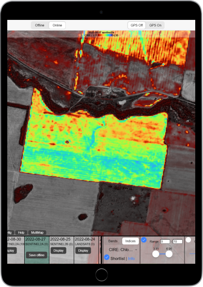
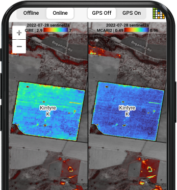
Agriobs uses the latest satellite remote sensing technology delivered through an app that works on any device both online & offline. We help businesses grow.
If you are an agronomist, farmer or other agribusiness seeking to use satellite imagery in your business, Agriobs will help you drive performance leveraging this valuable resource.
Agriobs is an application that accesses multiple sources of imagery with dynamic presentation and reporting tools. We provide an almost unlimited combination of processing options.
Agriobs is for businesses that truly want to improve their efficiency and help their clients perform.
We are a self-funded, Australian company looking to help businesses globally. Farming and software flows through our veins.
With multiple imagery sources built in you have the best chance of finding what you need. This includes Sentinel 2, Landsat 8 & 9, Landsat (4, 5 & 7) with more coming.
Export processed imagery to GeoTIFF.
Spectral indicies such as NDVI, Chlorophyl Red Edge, Water Index plus over 100 more available. There is a curated list, but we also import the entire library from Awesome Spectral Indices for you.
Fully dynamic range slider so you set your color scale range for maximum impact.
We use the Turbo color scale developed by engineers at Google.
Built in reporting tool so you can send custom branded imagery visualizations to your clients from within the app. In app address book to store client details. Save reports to refer back to.
Download individual bands to your device to you can continue to have all processing options available offline. Others just save a static picture.
We strive to help you with solid documentation. Not just on how to use our app but how to apply satellite imagery to your business more broadly.
Transparency thresholding provides a unique visual contrast between area of interest and the outlying area.
Organisation and member system that allows the company administrator to add and manage users with their account.
We are working on making Agriobs available in the iOS App Store. You can already use it in Safari and save it to your home screen, but the app is coming.
Agriobs is a progressive web app (PWA) that can be installed on Android devices and even Windows desktop machines.
Don't redraw your boundaries. Import them from Agworld exports. More import options coming soon.
We strive are adding features every week.
Some other tools include MultiMap view, GPS location tracker and area measurement.
Many products that offer satellite imagery limit your processing and visualisation options. We aim to sacrifice a little usability to empower the advanced user. Often complex problems and smart operators require advanced solutions.
You will need to spend time learning how to leverage Agriobs to it’s full potential. But we are here to help.
Reach out today to see how Agriobs can help your business.